For several years geologists debated the origin of these rocks. They now know that these extrusive volcanic rocks originated in eastern Oregon and flowed westward toward the Oregon Coast. The Cape Mears and Cape Lookout headlands are considerably younger than other volcanic rocks found in the Coast Range. They are between 6 and 15 million years old and flowed from long narrow cracks in the earths crust in the area near the Washington, Idaho and Oregon borders. Lava began to flow in unbelievable proportions from these crevices. It quickly started to fill valleys and kept on flowing. It covered hills and kept on flowing. It covered mountains and continued to flow. It flowed down the Columbia River valley and flowed all of the way to the Pacific Ocean.
Fifteen million years ago the Oregon Coast looked noticeably different from what it does today. At that time, the coastline was just forming as soft ocean sediments were being uplifted. The Columbia River flowed across western Oregon and emptied into the ocean near present day Newport. Geologists believe that the flows filled the Columbia River valley a number of times, each time pushing the river northward. This incredible outpouring of basalt is referred to as the Columbia River Basalt Flows. Many different flows occurred over a period of about 11 million years, the largest being the Grande Ronde Formation. It is mind boggling to think that the rock that makes up our ocean headlands originated over 400 miles away. It likely flowed through lava tubes that insulated the hot lava and kept it moving.
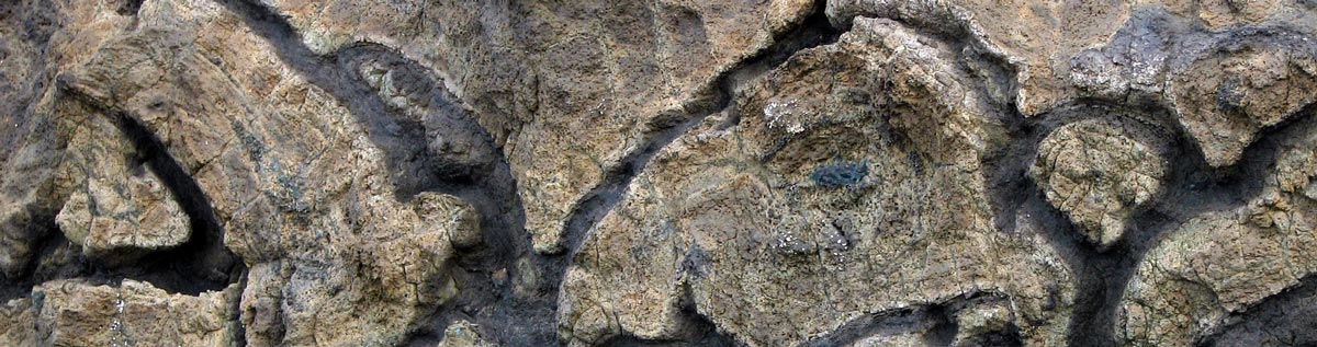
As the red-hot molten rock met the ocean it began to cool and harden. Geologists call basalt rock cooled in water, pillow basalts. They are different from other basalt rocks and can be recognized by their pillow like shapes with glassy surfaces. They tend to fracture easily when exposed to the elements of nature and have rounded or radial fracture lines. Look for them the next time you are walking the beach, especially at Maxwell Point. They contrast sharply with the columnar basalt also found in the Grande Ronde Formation.
The Grande Ronde basalt flows covered more than 55,000 square miles and filled the area with 36 cubic miles of basalt, in some places nearly a mile deep. Most of the activity occurred over a period of less than one million years. These flows now form ocean headlands at Seal Rock, Otter Rock, Depoe Bay, Yaquina Head, Cape Lookout, Cape Mears, Cape Falcon and Tillamook Head. The more erosion resistant basalt also caps Coast Range peaks such as Mt. Hebo and Saddle Mountain. Numerous theories are being debated among geologists as to what caused these massive flows to occur.
The layers of basalt are observable at several locations along the coast. At the Cape Mears State Park five distinct layers of basalt are noticeable from viewing platforms. Look for pillow basalt near the bottom and layers of basalt as you go up. This is another good location to see columnar basalt. The cracks and crevices between basalt layers make good nesting platforms for numerous birds such as the peregrine falcon. Above the basalt is light colored and golden or gray sandstone about 50 feet deep. Much of the sandstone has eroded away. The sandstone is younger than the underlying rock and sandwiched between another basalt flow layer, which is observable if you’re willing to hike or drive to the top of Cape Mears Mountain. This basalt layer is much younger and covers a smaller geographic area and is referred as the Frenchman Springs Member of the Wanapum Basalt.
The roads and beaches between Cape Mears and Cape Lookout offer many opportunities to observe remarkable geologic features. The next time you are admiring your favorite ocean view from a beach, rocky cliff or headland take a few moments to appreciate the origin of our magnificent coastline.
Text by Chris McDonald
Soil Scientist
Tillamook, Oregon