WYSIWYG Web Builder
Tides
A favorite time for both locals and visitors to explore the seashore is at low tide when the ocean recedes to reveal the myriad of animals and seaweeds that inhabit the sand and rocks, life that is otherwise hidden from view.  Low tides leave isolated tide pools that let us discover the biological zones that cover the vertical faces of rocks, where starfish prey on mussels living just above them, and green anemones show their faces to young children who gently poke fingers into their mouths and feel the tingle of tentacles that close around them.

Before heading to the shore, we often examine tide tables corrected for Tillamook County beaches, published locally by Coast Printing & Stationary, Inc. and distributed to local stores and other outlets.  Here we find the dates, times, and levels of tides.  Most of us take these tables on faith with only a little understanding of the processes behind them.  Where do all these times and values come from and what do they really mean?  We will try to provide some answers.
Reproduced here are tide tables for June 2005 and December 2005.  We can see from the these pages that there are usually two high tides and two low tides each day, A.M. and P.M., and that there is a higher high and a lower high and a higher low and a lower low, a phenomenon called “mixed tides.”  The favored minus tides (those below the mean of lower low water which is designated as the “zero level”) are highlighted in red.  If we look at the times of the tides on successive days, such as the AM high tides in December, we find that they occur later from one day to the next.  We may also notice that there is a series of low tides about every two weeks or so, usually the lower of the two lows in the morning (AM) during the summer and in the evening (PM), usually after dark, during the winter.  These are tides typical Oregon’s coast.  Other parts of the world may have diurnal tides, one high and one low a day, or semidiurnal tides with two highs and two lows of equal size.  Most people know that the tides have something to do with the moon, its gravitaional pull and its phase, and that the greatest tidal ranges are associated with full and new moons.  But why do we have all these various patterns that we find in the tide book?  Why do we have mixed tides?  Why are tides later each day?  Why is there a difference between summer and winter?  The answers are pretty complex!

First let’s look at what causes tides.  What makes the water rise and fall with respect to the land?  The good news is that there is only one thing that causes tides, and that is gravity.  In the case of the ocean tides, it is almost exclusively the gravity between the Earth and the Moon, and the gravity between the Earth and the Sun.

The bad news is that there are a lot of complicating factors that influence the actual height of the tides.  We will only touch on the most important of these.  Any two bodies in space exert an attractive force on one another.  We call this force “gravity”.  The strength of the gravitational attraction between two bodies depends on their masses and the square of the distance between them.  The tractive force that creates tides is also a function of the mass of the bodies involved.  The Sun and the Moon are the only bodies in space that have a significant effect on the tides, and because the Moon is so much closer to the Earth, even though it is much less massive than the Sun, it has roughly twice the tide producing force of the Sun.  When it comes to tides, distance trumps mass.

One of the most common questions asked about tides is why there is a high tide on the side of the Earth facing away from the moon.  Most of us have been taught that the Moon revolves around the Earth.  Actually the Earth and Moon both rotate around their common center of gravity called the “barycenter”.  Since the Earth is much larger than the Moon, the barycenter is much closer to the Earth's center than to the Moon's center.  It's a bit like playing on a seesaw with a little child.  The bigger parent has to be closer to the balance point (barycenter) to make the seesaw operate properly.  The Earth is so much more massive than the Moon that the barycenter is actually about 1000 miles below the surface of the Earth directly below the Moon.  The simplest way to think about the question of a tide on the side of the Earth opposite the Moon is to imagine the rotating Earth being replaced by a huge ball of water.  The Moon's gravitational attraction for the water on the near side of the ball is stronger than its attraction for the water on the far side of the ball.  On the far side of the ball, the centrifugal force created by the ball's spin is stronger that the gravitational pull.  The result would be a slight elongation of the ball along a line connecting the Earth and Moon.  Our elongated ball of water would create two bulges, one on the side nearest the Moon, and one on the opposite side.  This is what happens to our oceans on Earth - two tidal bulges (high tides) are created on opposite sides of the planet, with low tides between.  It is the result of what is called tidal gravity, the combination gravitational pull of the sun and moon on the ocean and the centrifugal inertia on the water created by the earth's rotation.  The exact same thing happens on a smaller scale between the Sun and the Earth.
High tide in Netarts Bay


Low tide in Netarts Bay
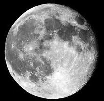
Someone is bound to ask, “If there is only gravity acting, why doesn't the Moon fall into the Earth?”  That's a good question.  The explanation is much the same as the explanation of how the International Space Station (ISS) avoids falling to Earth.  Actually both the ISS and the Moon are constantly falling toward the Earth, but the forward motion of each just balances the falling so that both Moon and ISS stay in orbit.  When astronauts want to return to Earth, how do they do it?  They slow down their return ship, and it simply falls back to Earth. No one wants the Moon to fall to Earth, so it's a good thing it isn't slowing down!

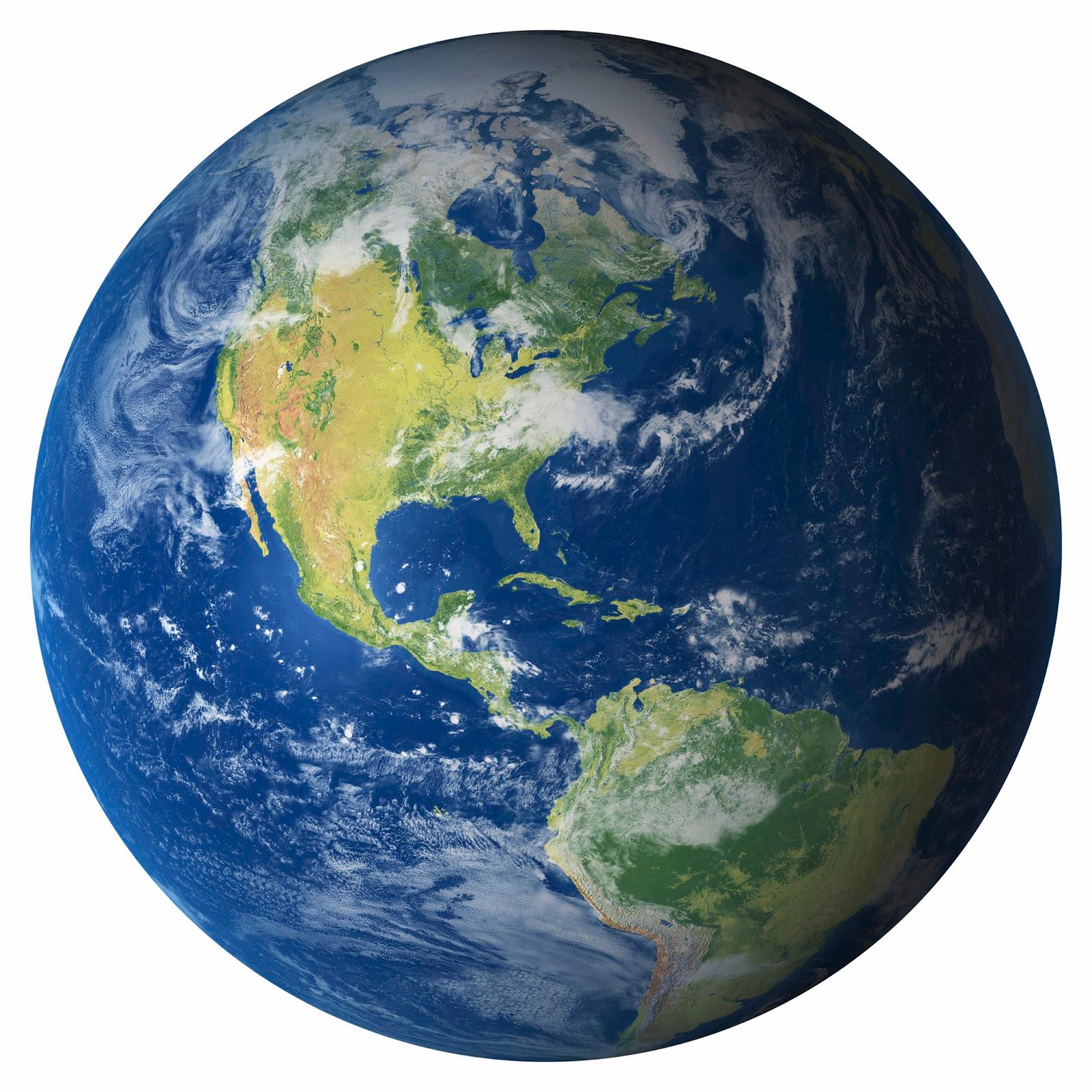
Scientists call the high tide below the Moon the “direct tide” and the high tide on the side opposite the Moon, the “indirect tide”.  Low tides are on the sides of the Earth at right angles to the high tides.  As the Earth rotates on its axis, any point on Earth, including Netarts Bay, passes through each of these tide bulges.  In a nutshell, that is why there are low and high tides.

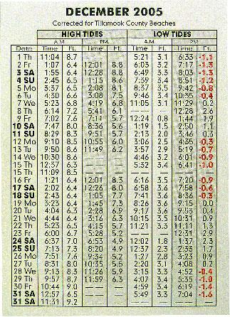
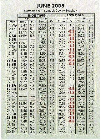
Why are the tides later on successive days?  Since we know that the earth rotates on its axis every 24 hours, we might expect to see both tidal bulges (high tides) pass us in that 24-hour period.  If we were standing on a beach, we would be prepared to see two high tides, each exactly 12 hours apart.  But when we look at our tide booklet, we find that the period between high tides on successive days is longer than 24 hours.  This is because the earth is not only turning on its own axis, but the moon and earth are also rotating on their common barycenter, which means that the moon is not at the same location after 24 hours, but has moved 12.2 degrees to the east, and the earth must rotate another 50 minutes for the moon to come overhead again.  This period of 24 hours and 50 minutes is called the lunar day, and it is the main reason for the times of the tides on successive days.  However, if you carefully examine the times of AM tides from day to day and do the math, you will see that they are not necessarily 12 hours and 50 minutes apart.  The period may be somewhat longer or shorter.  There are other factors, some of which are discussed below, that influence these times.

When the Moon, Earth, and Sun are positioned in a straight line at new or full Moon, the tide producing forces of the Sun and Moon are added together giving extra high tides and extra low tides called “spring tides.”  These are the best tides for beach combing, clamming, or visiting tidepools.  During the Moon’s first and last quarters the Sun and Moon act at right angles to each other, and the result is a much reduced tidal range called a “neap tide.”

The three bodies vary in distance from one another because of the shape of their orbits.  The orbit of the moon, for example, is an approximate ellipse.  During its sidereal month of 27.32 solar days, it travels closest to the earth at its perigee and farthest at its apogee, a difference of about 50,000 km (31,000 miles).  These changing distances have an affect on the range of tides, elevating tides at perigee and lowering tides at apogee.  Likewise the orbit of the earth around the sun is not quite circular.  All these changing distances due to orbits, with their gravitational augmentations and oppositions, begins to complicate the idealized picture of tides we began with.


Two other complicating factors are the declinations of the moon and the earth.  The moon's orbit is canted at an angle of five degrees to the ecliptic, the plane of the earth's orbit around the sun, causing it to move to angles north and south of the equator as it circles the earth.  This means that as the earth rotates, the tidal bulge on one side of the earth will face the moon when the moon appears above the equator and its pull will be from that angle.  Then a little more than 12 hours later, that same bulge will be on the side of the earth opposite the moon and the pull of the moon's gravity will be from below the equator.  This phenomenon causes what is called diurnal inequality and results in the mixed tides that we experience at Netarts Bay.  When you look at your tide tables, you will see that the A.M. tides, both lows and highs, are usually different from the P.M. tides and that there is a higher high and a lower high and a higher low and a lower low.  This is the most common tidal pattern along our coast.  There is a time as the moon travels around the earth that it is directly above the equator. In this case the tides are not mixed.  The highs and lows are of the same magnitude and are called semidiurnal tides.

The oceans of the earth are really just a thin film of water on the planet's surface.  They are thousands of miles across, but only a few miles deep, so that as the earth rotates, the tidal bulge caused by the moon's tractive forces has to try and catch up to the moon's zenith.  The relative shallowness of the oceans does not allow the wave of the bulge to travel fast enough to stay directly under the moon, and it lags by about 90 degrees.  This is why, as physicist James S. Trefil (1984) points out, the low tide occurs when the moon is overhead and we see high tide when the moon is near the horizon.


Now we come to landmasses.  If you look at a globe, the only part of the ocean that entirely circles the Earth is near the Antarctic.  Continents and islands with irregular shorelines interrupt the rest of the water on the planet, impeding the flow of the tidal bulges around the earth.  The details of land configuration and ocean bottom add another level of complexity to tide prediction.  For example, irregularities in the Bay of Fundy and the northern part of the Gulf of California cause tides of exceedingly high ranges, 50 and 30 feet, respectively.  Water that fills these areas does so at such a rapid pace that the friction of the bottom allows the top of the tidal flow to overtake the bottom of the flow to create a true tidal wave, what oceanographers call a tidal bore.

Our coast has few of these extreme configurations, but the tide flowing and ebbing through the narrow entrance of Netarts Bay can cause a stiff tidal current, though certainly not a bore, and the times of high and low tides within the bay differ from the times listed for the outer coast in our tide booklet.  If you look at the back side of the booklet you will find correction times for various locations around Tillamook County.  At the Netarts boat launch, for example, you need to add 51 minutes for high tide and 64 minutes for low tide.  It takes time fill and drain the bay.  There may be a lag Tides-8from minutes to hours as the tide progresses, depending on your location, and the farther into the bay you are, longer the lag.  This can be important, for example, to kayakers or crabbers who want to know precise times of tidal flows.
Olive snail.
At low tide across some sand flats in Netarts Bay you may encounter meandering and crisscrossing trails of the beautiful little purple olive snail.
Click here for more information!
So, finally, why are the lower low tides, the minus tides that allow us to dig clams and explore the hidden seashore, the tides marked in red in our tide book, in morning during summer and evening during winter?  The earth's axis is also tilted with respect to its orbit about the sun, an angle of 23.5 degrees.  This is what gives us our seasons.  During our summer, the sun shines more directly on the Northern Hemisphere, giving us longer days.  This also means that the diurnal influences of the sun are at a maximum during daylight hours.  During winter, it shines more directly over the Southern Hemisphere and we have winter and shorter days. At this time, the diurnal influences are at a maximum during the night.  This shift in the sun’s transit during the seasons accounts for the changes in the times of the lower low tides between summer and winter months.

All this complicated dance of the earth, moon, and sun, the influence of land masses is, admittedly, mind bending.  For our purposes, since the force of the moon is dominant in the creation of tides, we can look into the night's sky and, with some certainty, rely on its journey around the earth to know when we are going to have a series of high or low tides, then look at our tide tables to determine more exactly when are what they are.
Tides and Safety

When you climb out to rocks that have been exposed at low tide to fish or look at all the wonderful things that live there, please remember that the tide comes back in.  It is easy to get distracted and forget that the incoming tide can cut you off from shore.  Every year stranded people have to rescued, plucked off rocks by the Coast Guard because they did not pay attention to the tide.  Before you go on a low-tide outing, read the tide tables and plan accordingly.

References:

Williamson, Eugene P.  2001.  Understanding Tides.

Trefil, James S.  1984.  A Scientist at the Seashore.

Thurman, Harold V. and Alan P. Trujillo.  2003.  Introductory Oceanography.

Text and Photographs by Jim Young
Oceanside, Oregon
Netarts Bay Today is Sponsored by

Click on Logo to return to NetartsBayWEBS.org

P.O. Box 152
Netarts, OR, 97143